Andros Island
Andros island, the northernmost of the Cyclades, is a Janus-faced island: Sun-bleached and typically Cycladic (barren, rocky) to the north (where is is separated from Southern Evia by the Strait of Kafireos, or Doro Passage) the island is a watershed to the southeast, where springs keep its valleys and hillside villages full of flowers year around.
Some geologists maintain that this abundance of water has its source in the Evian mountains, reaching Andros through seabed aquifers. Whatever its origins, the water of Andros island, especially that bottled at Sariza, both still and sparkling, is as famous throughout Greece as Perrier and Badoit are in France. Tourists of another era came to Sariza to ''take the waters''; today's visitors are just as likely to come to Andros for the salt variety lapping the island's numerous and uncrowded beaches and coves.
As paradoxical as the island's geography is the makeup of the modern tourist population. The island, especially Chora, the capital town, is home away from home to many of Greece's wealthiest shipowners and businesspeople. They built palatial homes here and raise thoroughbred horses in the nearby countryside. This Greek ''ship-set'', their offspring, and Athenian friends invade for a short holiday stay between June and August. But another group is already in evidence: the package tourists.
As early as April organized and relentless foreign groups, primarily British, flood specific areas of Andros-not, of course, those enclaves frequented by the rich and famous. The two sets pass on the serpentine coast road but do not mingle.
Strangely enough, few other types of visitors have been attracted to the island, and therein lies the challenge. Discerning travelers may still find on Andros-well away from the tour-infested areas such as Batsi - unspoiled villages and ''private beaches''. But because of the resident aristocracy;s unwillingness to allow building in their well-manicured backyards, as it were, Andros is not as accessible as its Cyclades neighbours to the south.
Bus connections are inadequate, information on archaeological sites is sketchy, coach tours are few. On Andros settle in at one of the handful of excellent new hotels and then set out, by rented car and then on foot, to explore. Of the Cyclades, 373-square-mile Andros, smaller only than Naxos, is a big island to make one's own.

Unfortunately, on Andros island all ferries dock at Gavrio on the northwest coast. In summer the port town is as stark and dusty as a de Chirico, as though Andros were trying to discourage all comers. There are three important tasks to accomplish in Gavrio before leaving, however: Acquire a map; rent a car, if you have not brought your own; and book tickets on a steamer out, if you failed to do so in Athens of Rafina.
The Tower of Ag. Petros 3km east of Gavrio, is one of the island's unique, if inscrutable sites. This 65 foot freestanding tower,part of which may date from the 14th century B.C. is an archeological enigma. What the structure was used for is unknown.
To reach the resort of Batsi, turn right out of Gavrion and proceed south on the coast road. The 8-km drive will take you past accessible beaches and rocks to the fine sandy beaches around the headland, before the amphitheatrical situated town of Batsi proper. Batsi is a fishing village that just grew. Busy as it is in the summer, the holiday atmosphere may be attractive to some travelers.
Nine kilometers farther south on the coast road is the three-shaded village of Paleopolis. Present-day Paleopolis is situated atop a steep hill that runs down to the sea where the ancient capital site was located, part of it now underwater. You can descend the 1,309 steps to the beach, but if you are interested on antiquities you will find little of interest either here or at the site of Zagora farther south, which in any case is closed to visitors. Both sites' rich finds are now housed in the Archaeological Museum in Chora, including the famous Hermes of Andros and late-Geometric-period finds from Zagora.

Fifteen kilometers south of Batsi at Stavropeda are the main crossroads of the island. Here you may turn left and proceed to Chora through rolling pastoral countryside dotted with villages and Medieval dovecotes, or bear right for Korthion. Chora , or Andros town,is a 12-km drive from Stavropeda. After the drama of the precipitous coast road, the drive inland exhibits the other, more bucolic, face of Andros.
Off the main road to Chora are the lush villages of Menites and farther north, Apikia. Menites, where springs gush out of the hill through the mouths of marble lions, is a cool, green grotto. The road dead-ends beneath enormous trees and the church of Virgin Koumoulos(Plentiful).
Apikia, 2,5km north of Menites, another hillside village, is the source of the Andro's famous Sariza water.
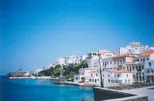
Chora itself, in the middle of the island's east coast, is the most interesting destination on Andros Island. Here are the ruins of the Venetian fort of Mesa Kastro, the Maritime Museum and,adjacent, Michael Tombro's bland but monumental statue of the Unknown Sailor. The maze of streets that form Kato Kastro, the Medieval city, and the 18th and 19th century mansions of the Riva District are all situated on a narrow, rocky peninsula between the twin anchorages of Paraporti and Embrio bays. Both bays have fine, if somewhat exposed beaches.
Andros island has no airport, but getting there by hydrofoil from Piraeus or by ferry boat from the mainland port of Rafina is relatively easy. In summer buses leave for Rafina from Mavromateon Street, adjacent to Aeros Park in the centre of Athens on an average 20 minutes, from 6.00am to 9.00pm.
List your business in this island for FREE
Do you own a restaurant, hotel, club, vacation rental or other business in this island? Fill out the form below and your business will be listed for free on my website.(Personal Information won´t be published)
You will have a whole personal page of your business on our site!!!
return from "Andros Island" to "Greek Islands"page


